Major road closures continue across Central Darling Shire
Kimberly Grabham
18 August 2025, 8:00 PM
Central Darling Shire Council's latest road condition report reveals ongoing challenges for motorists, with several key routes remaining closed and the majority of secondary roads under caution conditions as of 17 August 2025.
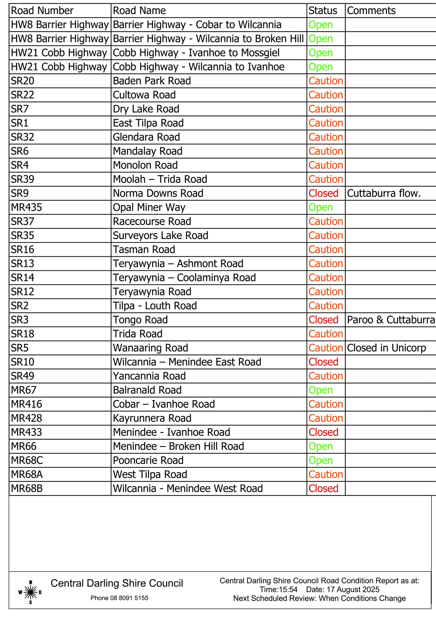
The region's primary transport arteries continue to operate normally, with both sections of the Barrier Highway (HW8) between Cobar and Wilcannia, and Wilcannia to Broken Hill remaining open. Similarly, the Cobb Highway (HW21) sections from Ivanhoe to Mossgiel and Wilcannia to Ivanhoe are accessible for through traffic.
Several important regional connections remain impassable, creating significant detour requirements for local and through traffic:
Norma Downs Road (SR9) remains closed due to Cuttaburra flow, indicating ongoing water course impacts affecting this route.
Tongo Road (SR3) is closed at both Paroo and Cuttaburra locations, suggesting widespread water-related disruptions along this corridor.
Wilcannia – Menindee East Road (SR10) remains completely closed, severing a key connection between these two major townships.
Menindee - Ivanhoe Road (MR433) is also closed, further limiting connectivity in the eastern portion of the shire.
Wilcannia - Menindee West Road (MR68B) closure compounds access issues between these population centres.
Widespread Caution Conditions
The majority of the shire's secondary road network operates under caution conditions, requiring reduced speeds and careful driving. Notable routes include:
Multiple roads around Teryawynia (SR12, SR13, SR14)
Key agricultural access roads such as Tilpa-Louth Road (SR2), Cultowa Road (SR22), and Baden Park Road (SR20)
Tourism and mining access routes including Racecourse Road (SR37) and Surveyor's Lake Road (SR35)
Wanaaring Road (SR5) carries the additional complexity of being closed within Unincorp, while maintaining caution status elsewhere along its length.
Only a handful of roads maintain full operational status, including Balranald Road (MR67), Pooncarie Road (MR68C), and Menindee – Broken Hill Road (MR66), along with Opal Miner Way (MR435).
The current road conditions significantly impact:
Inter-town connectivity: Multiple closures between Wilcannia and Menindee create substantial detour requirements
Agricultural access: Numerous farming and grazing properties face restricted access via caution-rated roads
Tourism and recreation: Access to popular fishing and camping areas around lakes and watercourses remains compromised
Emergency services: Multiple route options remain limited for emergency response vehicles
Central Darling Shire Council continues monitoring conditions across the 53,000 square kilometre local government area. The next scheduled review will occur when conditions change, rather than at a fixed interval, reflecting the dynamic nature of weather and water course impacts affecting the region.
are advised to check current conditions before travelling and allow extra time for journeys requiring detours around closed routes. The council can be contacted on 08 8091 5155 for specific road condition enquiries.
Current conditions reflect the ongoing challenges faced by one of Australia's largest local government areas in maintaining connectivity across vast distances and variable weather conditions.
NEWS

SPORT

RURAL

COMMUNITY